Wednesday, June 29

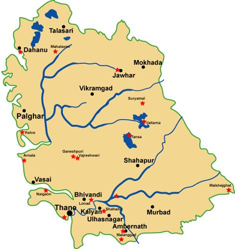
Talukas in Thane District | Thane District Map | Maharashtra Villages

About Thane District

Thane is one of the few industrially advanced districts in the state of Maharashtra. Thane district is on the North of Konkan division. According to census 2011, it is third in the state in terms of population. Area of ​​the district is 4214 sq. Km. It is 1.37 percent of the state. The Sahyadri mountain ranges to the east and the Arabian sea to the west, the dense forest section of the Gujarat state on the north, and the south of Mumbai, which are considered to be world famous and the financial capital of India, are the four pillars of this district. The industrial area developed in Thane, Kalyan, Ulhasnagar, Ambernath, Bhiwandi talukas of the district and are under influence of Mumbai city’s modern culture. Out of 720 KM of coastal coast of Maharashtra State, Thane district has benfitted by 27 KM of coastal coast. 7642 hectare area is suitable for ground water fishing. Along with marine fishing, groundwater fishing is done as well. A big market like Mumbai is available for fishery and there is a great demand for fish production from the Gulf countries also.

In terms of industrial development Thane district is third in the state. Economic and social development of more than half of the district is due to industrialization. Maharashtra Industrial Development Corporation have developed 8 industrial estates. The international market and friendly ports like Mumbai, the convenience of communication and the facilities provided by the government, have made the industry prosperous in the district. Especially in the southern and western parts of the district, there is a centralization of industries. The industries registered in the district mainly produce large amounts of chemicals and medicines. Apart from this, medium and small producers of plastic goods, iron goods and powerloom fabrics are being manufactured in large quantities. After the Ichalkaranji in Maharashtra, the textile industry of Bhiwandi is known for its textile industry. The Central Government sponsored ammunition and arms manufacturing factory is at Ambernath. Due to increasing industrialization, large scale employment has been generated to skilled and unskilled workers. Although the mineral production is not very much in the district, the business of sand excavation for the construction works on a large scale in Mumra, Thane and Ghodbunder.

 
Thane District Map

List of Taluka’s in Thane

  1. Thane
  2. Kalyan
  3. Murabd
  4. Ulhasnagar
  5. Ambarnath
  6. Bhiwandi
  7. Shahapur


Monday, June 27

Talukas in Sindhudurg District | Sindhudurg District Map | Maharashtra Villages

Sindhudurg District History:

Sindhudurg district is spread over an area of around 5,207 sq.kms. The population of the District is 8,68,825 as per census of 2001. The modern township of Sindhudurg Nagari is the headquarters of Sindhudurg district . The district is surrounded by the Arabian Sea on the west, the Belgaum District (Karnataka state) and Goa on the South and the Ratnagiri district on the North. Sindhudurg being a coastal district, the climate is generally moist and humid and the temperature variations during the day and throughout the seasons are not large. Sindhudurg is accessible by road on the NH-17 which passes through major towns of Kankavli, Kudal and Sawantwadi or by the picturesque journey on the Konkan Railway which stops at Kankavli,Sindhudurg, Kudal and Sawantwadi. The nearest airports are at Ratnagiri, Belgaum (Karnataka) and Dabolim (Goa).


Sindhudurg District Map

List of Taluka’s in Sindhudurg

  1. Kudal    
  2. Sawantwadi    
  3. Kankavli    
  4. Devgad    
  5. Malwan    
  6. Vengurla    
  7. Dodamarg    
  8. Vaibhavvadi

Saturday, June 18

Talukas in Ratnagiri District | Ratnagiri District Map | Maharashtra Villages

Ratnagiri District History:

Ratnagiri is the birthplace of Lokmanya Tilak as well as the workplace of Swatantryaveer Savarkar and Ratnagiri is known as the land of Vardamuni, Parshuram. In the Middle Ages, many European travelers and regiligious preachers visited the coast of Konkan. The ancient Konkan was ruled by Maurya, Satvahan, Trakootak, Chalukya, Rashtrakut, Shilahar, Kadamba and Yadav dynasties. During the Satavahana, the caves of Panhalakaji were the center of the study and spread of Buddhism. It is also mentioned at many places that there was sea trade between Ratnagiri and overseas. Ratnagiri is the land of three ‘Bharatratn’, such as Dr. Babasaheb Ambedkar, P.V. Kane and Maharshi Dhondo Keshav Karve. Apart from this, King Thiba of Bramhadesh was imprisoned in the Ratnagiri district by the then British government. Citizens of Myanmar and high officials visit time to time to Thiba Palace and Thiba King Tomb in Ratnagiri city. Ratnagiri district has become welknown, due to freedom fighter Vinayak Damodar Savarkar, who had been captured in Ratnagiri by the British government.


List of Taluka’s in Ratnagiri

  1. Ratnagiri
  2. Chiplun
  3. Sangameshwar
  4. Khed
  5. Dapoli
  6. Rajapur
  7. Guhagar
  8. Lanja
  9. Mandangad


Talukas in Chandrapur District | Chandrapur District Map | Maharashtra Villages

Chandrapur History:

The district Chandrapur was earlier known as ‘Chanda’ according to tradition and legend the name of the place was ‘Lokapura’ which was first changed to ‘ Indpur’ and subsequently to Chandrapur. During the British colonial period it was called Chanda district, which was again changed to its original name ‘Chandrapur ‘ around 1964. Other places of the region in ancient times include wairangad, Kosala, Bhadravati and Markanda. Hindu and Buddhist kings are said to have ruled the area for a long time, Later on Gonds overtook Dana Chiefs who ruled Chandrapur around 9 th century and Gond Kings ruled the area till 1751 after which Maratha period started. Raghuji Bhosale, the last King of the dynasty, died heirless in 1853 and Nagpur province together with Chandrapur was declared annexed to British Empire.

In 1854, Chandrapur formed and independent district and in 1874, it comprised of three tehsils Viz Mul, Warora and Bramhpuri. In 1874, however, upper Godavai district of Madras was abolished and four tehsils were added to Chandrapur to form one tehsil with Sironcha as its headquarters. In 1895, the headquarters of one tehsil transferred to MUl to Chandrapur. A new tehsil with headquarter at Gadchoroli was created in 1905 by transfer of zamindari estates from Bramhpuri and Chandrapur tehsil. An small zamindari tract from Chandrapur district as transferred to newly from districts in 1907. In the same year and area of about 1560 sq. km. comprising of three divisions of the lower Sironcha tehsil namely Cherla, Albak nad Nugir were transferred to Madras State.

No major changes occurred in the boundaries of the district or its tehsils between 1911-1955. Consequent upon reorganization of the states in 1956, the district was transferred from Madhya Pradesh to Bombay state. In the same Rajura tehsil, a part of Adilabad district of Hydrabad state, was transferred to Nanded district subsequently it was transferred to Chandrapur district in 1959. the district became part of the Maharashtra since its creation in May 1960. For administrative convenience and industrial and agricultural development , this district was again divided into Chandrapur and Gadchiroli district after 1981 census. Chandrapur district now comprises of the tehsil of Chandrapur , Bhadravati, Warora, Chimur, Nagbhir, Bramhpuri, Sindhewahi, Mul, Gondpipri, Pomburna, Saoli, Rajura, Korpana, Jivati and Balharshah.


List of Taluka’s in Chandrapur –

  1. Chandrapur
  2. Warora
  3. Chimur
  4. Brahmapuri
  5. Bhadravati
  6. Rajura
  7. Ballarpur
  8. Nagbhir
  9. Korpana
  10. Mul
  11. Sindewahi
  12. Sawali
  13. Gondpipri
  14. Jiwati
  15. Pombhurna