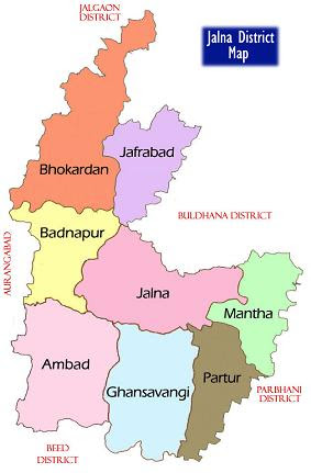
About Jalna District
Jalna is a district in the Maharashtra State of India. Total area of Jalna is 7,694 km² including 7,587.95 km² rural area and 106.16 km² urban area. As per 2011 stats, Jalna has a population of 19,59,046 peoples, out of which urban population is 3,77,429 while rural population is 15,81,617. The district has a population density of 254.8 inhabitants per square kilometre. There are about 3,91,701 houses in the district, including 70,793 urban houses and 3,20,908 rural houses. When it comes to villages, there are about 958 villages in jalna district.
Jalna district erstwhile a part of Aurangabad district was formed on 1st May 1981 by carving out Jalna, Bhokardan, Jafrabad, Ambad tahsils of Aurangabad district and Partur tahsil of Parbhani district.The boundaries of Jalna district are adjacent to Parbhani & Buldhana on east, Aurangabad on west, Jalgaon on north and Beed on south.Jalna district covers an area of 7,612 Sq.Kms, which is 2.47% of the total state area.
The district head quarter is at Jalna & well connected to state capital and national capital by broad gauge railway line. Major towns of the state are also connected by state highways. Jalna district is well known for it’s hybrid seed industries, steel re-rolling mills, bidi industry & agro based industries like dal mill. The district is also known for the highest production of Sweet Lemon(Mosambi) in the state.
Bhokardan is the largest tehsil in jalna district covering area of 1177.42 km² while Jafferabad is the smallest tehsil in jalna district covering area of 724.50 km². Jalna is the most populous whereas Badnapur is the least populous tehsil in jalna district. There are 8 tehsils in Jalna district. Here is the list of all Jalna Tehsils / Blocks / C.D.Blocks along with area & population information
| Sr. No. | Tehsil | Area (km²) | Population (2011) |
|---|---|---|---|
| 1 | Ambad | 1,159 | 2,55,709 |
| 2 | Badnapur | 778 | 1,53,772 |
| 3 | Bhokardan | 1,177 | 3,11,303 |
| 4 | Ghansawangi | 1,119 | 2,11,108 |
| 5 | Jafferabad | 725 | 1,63,120 |
| 6 | Jalna | 1,168 | 5,19,018 |
| 7 | Mantha | 823 | 1,67,427 |
| 8 | Partur | 738 | 1,77,589 |
Tourist places: Jalna Fort,Moti Lake,Chhatrapati Sambhaji Garden,Ghanewadi Lake, Swami Vivekanand Ashram
How to Reach: Jalna is a small town and a part of Aurangabad division. It is spread over an area of 7718 km². The district is surrounded by Jalgaon district in north, Parbhani and Buldhana districts on the east, Beed district on the south and Aurangabad district on the west. Shree Ganesh, Mastyodari Devi, Jamb Samarth, Ghansawangi Tq, Jalicha Dev, Anand Swami, Mamma Devi, Kali Masjid, Guru Ganesh Bhavan are some of the prime Jalna attractions that are worth visiting. Chikkalthana Airport is situated at a distance of 51 km from Jalna. It is a public airport situated in Aurangabad, India. There are number of airlines that are providing their esteemed services to passengers. Delhi, Hyderabad, Mumbai and Nanded are some of the cities that are connected by air facilities from this airport. From Jalna Railway Station, you can take trains for different cities of the country. The town is well connected with efficient roadway system as well.
By Air: Jalna does not have an airport. Nearest airport is Chikkalthana Airport. Jalna64 km away from Chikkalthana Airport (IXU), Aurangabad, Maharashtra.
By Train: You can easily get regular trains to Jalna from other major cities of the country. Railway Station : Jalna (J)
By Road:
There are regular buses from other major cities of the country to Jalna.
Bus Station : Jalna.

No comments:
Post a Comment