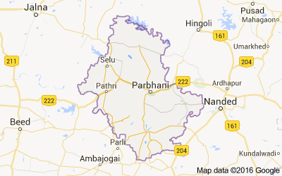
Parbhani, earlier also known as “ Prabhavatinagar ”, is one of the Eight districts in the Marathawada region of Maharashtra State
This entire Marathwada region, a district geographical region, was a part of the erstwhile Nizam State; later a part of Hyderabad State; after reorganization of states in 1956 it became a part of the then Bombay state; and from 1960 onwards it is part of the present Maharashtra state.
Parbhani district lies between 18.45 and 20.10 North Latitudes and 76.13 and 77.39 East Longitude.
The district is bounded on the north by Hingoli district. On the east by Nanded district, on the South by Latur and on the West by Beed and Jalna districts.
The state capital of Mumbai is to the west; Parbhani is well connected by road to other major towns in Maharashtra and also in the neighboring state of Andhra Pradesh.
Parbhani is one of districts of Maharashtra in India, Parbhani District population in 2022 is 1,964,700 (estimates as per aadhar uidai.gov.in Dec 2020 data). As per 2011 census of India, Parbhani District has a population of 1,836,086 in 2011 out of which 942,870 are male and 893,216 are female. Literate people are 1,157,814 out of 666,291 are male and 491,523 are female. People living in Parbhani District depend on multiple skills, total workers are 822,797 out of which men are 501,422 and women are 321,375. Total 281,771 Cultivators are depended on agriculture farming out of 172,500 are cultivated by men and 109,271 are women. 288,438 people works in agricultural land as labor, men are 148,417 and 140,021 are women. Parbhani District sex ratio is 947 females per 1000 of males. Next Parbhani District Census will be in 2022-2023.
Taluka wise Number of Gram Panchayats Chart of the District Parbhani :-
| Sr.No | Taluka Name | No of Grampanchyat |
|---|---|---|
| 1 | Gangakhed | 107 |
| 2 | Jintur | 172 |
| 3 | Manwath | 55 |
| 4 | Palam | 82 |
| 5 | Parbhani | 131 |
| 6 | Pathri | 57 |
| 7 | Purna | 94 |
| 8 | Sailu | 95 |
| 8 | Sonpeth | 58 |
District At a Glance :
- Area: 6,250.58 Sq. Km
- Population: 18,36,086
- Language: Marathi
- Villages: 848
No comments:
Post a Comment