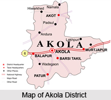
 Akola district is one of the districts located in the state of Maharashtra. Akola District, with the rest of Berar was assigned to the British East India Company by the Nizam of Hyderabad following the Treaty of Assignment of 1853. After the Province was assigned to the Company it was divided into two districts, East Berar and West Berar, Akola being the headquarters of the latter. In 1903 the Treaty of Assignment was superseded by an agreement under which the Nizam ceded Berar to the Government of India in perpetuity. Administration of Berar was then transferred from the Resident of Hyderabad to the Chief Commissioner of Central Provinces. The area which now forms the present Akola district was created by the transfer of Murtizapur tahsil from Amravati to Akola district and by the transfer of Khamgaon and Jalgaon tahsils from Akola to Buldhana district. Washim district was broken up and two of its tahsils, viz., Washim and Mangrul, were included in Akola district. The famous 'Mahabeej' factory, producing super-quality seeds is located here. Vidarbha's only Agricultural University is also situated here. Narnala fort in Akot taluka, Parshwanath Jain Temple of Shirpur, Rajrajeshwar temple, power generation plant of Paras, the irrigation project in Mahan on Katepurna river are among the places of tourist attraction.
Location of Akola District
The district of Akola lies in the western parts of the Nagpur Division of Maharashtra State and is surrounded by Amravati district in the north and north-east, Yavatmal district in the south-east, Parbhani district in the south and Buldhanat distric in the west. The district lies between 19 degrees 51 minutes and 21 degrees 16 minutes latitude and 76 degrees 38 minutes and 77 degrees 44 minutes longitude. It has a total area of 10,567 square kilometres.
History of Akola District
Akola district came into being on 1st July 1998. It was initially a part of the Nizam's dominions. It came under the British East India Company in 1853 as debt repayment and as a future guarantee for payment. In 1857, Berar was divided into east and west Berar, and the latter had its headquarters at Akola. In 1903, the treaties of assignment were superseded by an agreement under which the Nizam leased Berar to the Government of India for an annual rent of 25 lakhs of rupees in perpetuity. The district continued to be a part of the organisation and re-organisation of states and districts within the country. There were no major changes in the boundaries of the district between 1911 and 1955. In 1956, with the Reorganisation of States, the district was transferred from Madhya Pradesh to the then Bombay State and in 1960 it became a part of the State of Maharashtra. Akola district as known today finally came into being on 1st July 1998, after its division into Akola and Washim district.

Geography of Akola District
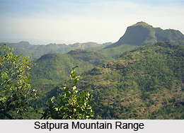
The topography of Akola district is such that the district can be seen divided into three parts. This includes the narrow northern strip at the foot if the Satpura Mountain range, Payanghat or Purna plains in the middle and the Balaghat on the top of the Ajanta ranges. Among the major rivers flowing in the district are the Purna River and the Penganga River flowing here along with their tributaries. The weather in the district is generally hot and dry, with high humidity.
Economy of Akola District
Agriculture dominates the rural economy and even the urban landscape to a considerable extent. Manufacturing and household industry barely account for 15 percent of the working population while services, trade and commerce account for a greater proportion in this district. Factory manufactures are insignificant and relatively recent. Industries are agro-based, viz. cotton ginning and pressing, spinning and weaving, and flour mills, oil crushing and dal mills.
(Last Updated on : 20/10/2014)
View Original Article here- https://www.indianetzone.com/46/akola_district.htm
No comments:
Post a Comment