Thursday, July 28

List of Villages in Pune District, Pune, Maharashtra

List of Villages in Pune District, Pune, Maharashtra

Pune district is the most populous district in the Indian state of Maharashtra. The district's population was 9,429,408 in the 2011 census, making it the fourth most populous district amongst India's 640 districts. This district has an urban population of 58.08 percent of its total. It is one of the most industrialized districts in India. In recent decades it has also become a hub for information technology.  


Tahsil-wise list of census villages in Pune district, Maharashtra, India
Sl NoTahsilTotal Villages
1Ambegaon144
2Baramati118
3Bhor196
4Daund104
5Haveli128
6Indapur144
7Junnar184
8Khed192
9Mawal192
10Mulshi147
11Pune City4
12Purandhar111
13Shirur118
14Velhe130


 Talukas in Pune District | Pune District Map | Maharashtra Villages

Tuesday, July 19

Talukas in Gadchiroli District | Gadchiroli District Map | Maharashtra Villages

Gadchiroli district was carved out on the 26th of August 1982 by the division of erstwhile Chandrapur district. Earlier, it was a part of Chandrapur District and only two places namely Gadchiroli and Sironcha were tahsils of Chandrapur District before the formation of Gadchiroli District.

Gadchiroli tahsil was created in 1905 by transfer of Zamindari Estate from Brahmapuri and Chandrapur tahsil. Gadchiroli district was created on August 26, 1982 by bifurcating the Chandrapur district in the place of Brahmapuri, which is part of the Vidarbha region of Maharashtra. In ancient times the region was ruled by the Rashtrakutas, the Chalukyas, the Yadavas of Deogiri and later the Gonds of Gadchiroli. In the 13th century Khandkya Ballal Shah founded Chandrapur. He shifted his capital from Sirpur to Chandrapur. Chandrapur subsequently came under Maratha rule. In 1853, Berar, of which Chandrapur (then called Chanda until 1964) was part, was ceded to the British East India Company. In 1854, Chandrapur became an independent district of Berar. In 1905, the British created the tehsil of Gadchiroli by transfer of Zamindari Estate from Chandrapur and Brahmapuri. It was part of the Central Provinces till 1956, when with the reorganisation of the states, Chandrapur was transferred to Bombay state. In 1960, when the new state of Maharashtra was created, Chandrapur became a district of the state. In 1982 Chandrapur was divided, with Gadchiroli becoming an independent district in the place of Brahmapuri.

 Gadchiroli District Map

Taluka wise Number of Gram Panchayats Chart of the District Gadchiroli :-

Sr.No Taluka Name No of Grampanchyat
1 Aheri 184
2 Armori 103
3 Bhamragad 128
4 Chamorshi 204
5 Desaiganj (Vadasa) 37
6 Dhanora 228
7 Etapalli 197
8 Gadchiroli 123
9 Korchi 133
10 Kurkheda 128
11 Mulchera 68
12 Sironcha 148

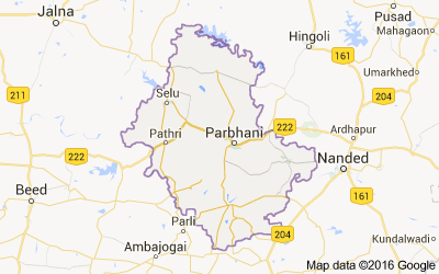
Talukas in Parbhani District | Parbhani District Map | Maharashtra Villages

Parbhani, earlier also known as “ Prabhavatinagar ”, is one of the Eight districts in the Marathawada region of Maharashtra State

This entire Marathwada region, a district geographical region, was a part of the erstwhile Nizam State; later a part of Hyderabad State; after reorganization of states in 1956 it became a part of the then Bombay state; and from 1960 onwards it is part of the present Maharashtra state.

Parbhani district lies between 18.45 and 20.10 North Latitudes and 76.13 and 77.39 East Longitude.

The district is bounded on the north by Hingoli district. On the east by Nanded district, on the South by Latur  and on the West by Beed and Jalna districts.

The state capital of Mumbai is to the west; Parbhani is well connected by road to other major towns in Maharashtra and also in the neighboring state of Andhra Pradesh.

Parbhani is one of districts of Maharashtra in India, Parbhani District population in 2022 is 1,964,700 (estimates as per aadhar uidai.gov.in Dec 2020 data). As per 2011 census of India, Parbhani District has a population of 1,836,086 in 2011 out of which 942,870 are male and 893,216 are female. Literate people are 1,157,814 out of 666,291 are male and 491,523 are female. People living in Parbhani District depend on multiple skills, total workers are 822,797 out of which men are 501,422 and women are 321,375. Total 281,771 Cultivators are depended on agriculture farming out of 172,500 are cultivated by men and 109,271 are women. 288,438 people works in agricultural land as labor, men are 148,417 and 140,021 are women. Parbhani District sex ratio is 947 females per 1000 of males. Next Parbhani District Census will be in 2022-2023.

Parbhani District Map


Taluka wise Number of Gram Panchayats Chart of the District Parbhani :-

Sr.No Taluka Name No of Grampanchyat
1 Gangakhed 107
2 Jintur 172
3 Manwath 55
4 Palam 82
5 Parbhani 131
6 Pathri 57
7 Purna 94
8 Sailu 95
8 Sonpeth 58

District At a Glance :

  • Area: 6,250.58 Sq. Km
  • Population: 18,36,086
  • Language: Marathi
  • Villages: 848

Talukas in Osmanabad District | Osmanabad District Map | Maharashtra Villages

Talukas in Osmanabad District | Osmanabad District Map | Maharashtra Villages 

Osmanabad District Map

Osmanabad district lies in the southern part of state. Most of the district area is rocky while the remaining part is plain. The height of district is 600 mm above sea level. Most part of the district is surrounded by small mountain called “Balaghat”. Bhoom, Washi, Kalamb, Osmanabad & Tuljapur Tahsil lie in the range of this Balaghat mountain.Some part of the major rivers like Godawari and Bhima come under this district.
The district is located on east side of Marathwada region within North latitude 17.35 to 18.40 degree and east latitude 75.16 to 76.40 degree.

The district is surrounded by following districts:

Solpaur – South-west
Ahmednagar – North-west
Beed – North
Latur – East
Bidar & Gulbarga (Karnataka) – South

The area of district is 7512.4 sq. km out of which 241.4 sq km is urban area ( 3.21 % of total area ) and 7271.0 sq km is rural area ( 96.79 % of total area).

Taluka wise Number of Gram Panchayats Chart of the District Osmanabad :-

Sr.No Taluka Name No of Grampanchyat
1 Osmanabad 110
2 Tuljapur 107
3 Omerga 80
4 Lohara 45
5 Kallamb 91
6 Bhum 74
7 Paranda 72
8 Washi 43