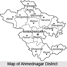
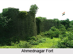
Ahmednagar District is the largest district in the State of Maharashtra. The district echoes the history of the past. The Ahmednagar fort at Ahmednagar is a place of historical importance. It is at this fort where many of our freedom fighters were detained during the Indian Freedom Movement. It was here that Late Pandit Jawaharlal Nehru was detained during Indian freedom movement and it was at this fort he wrote his famous book "Discovery Of India".
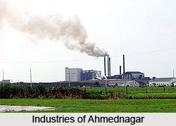
Today, Ahmednagar is a most advanced district having maximum number of large scale and small-scale industries.
Origin of name of Ahmednagar
The name of the District
Ahmednagar has come from the name of the founder, Ahmed Shah Nizam Shah.
History of Ahmednagar
The history of Ahmednagar begins from 240B.C. In the beginning it was not a place of district importance. There were only small hamlets in the neighborhood of the city.
It was the Andhrabrityas who ruled Ahmednagar B.C. 90 to A.D. 300. Till about 400 AD, Ahmednagar was ruled over by the Rashtrakuta Dynasty. Till 670 AD, Chalukya & Western Chalukya kings ruled the country. The Rashtrakuta kings then ruled Ahmednagar from 670 to 973 A.D. Govind III was the mightiest of the Rashtrakutas whose kingdom stretched from Marwar and Rajputana in the north to Tungabhadra river in the south. Then followed the Western Chalukyas whose dynasty ruled from 973 to 1190 A.D. The caves and temple of the city were carved and built during this period. After the Western Chalukyas, Ahmednagar passed on to the hands of the Yadavs from Deogiri, who ruled from 1170 to 1310. The famous king of Yadav was Ramdeorao and his name is mentioned in the works of the saint of Dnyandeo. The most notable minister of this time was Hemadri who invented modi script. He was a genius and created the idea of constructing buildings without the help of lime stone and mortar instead, place well cut stones of medium size across each other and filling upon each other in particular angles in such a manner that walls would be erected forming the shape of temple.
Alladin Khilaji, the commander-in-chief of the Moghal king of Delhi in 1294, defeated the king. This victory at the very invasion gave a stimulus to the Muslim ambition of establishing Muslim stronghold in the Deccan. Governors appointed from Delhi then ruled Maharashtra. In 1338, the emperor of Delhi, Mohommed Tughla made Deogiri his capital and changed its name to Daulatabad. Later, Tughlak left Daulatabad and then his noblemen harassed the natives by plundering their wealth.
Alladin Hasan Gangu, an Afgan soldier was successful in overthrowing the power of Delhi emperors and establishing an independent sovereign kingdom known as Bahamani or Brahmin kingdom. After his death, due to the inefficiency of the next king, the Bahamani kingdom was divided into five independent kingdoms and Ahmednagar was one among them known as Nizamshahi. The kingdom was then ruled by Mohmad Gawan, which was later succeeded by Nizam-ul_mulk. In 1485, he added Bhir and Ahmednagar to his estates. The management of this area was given to the minister's son Malik Ahmad, the founder of the Nizamshahi Dynasty of Ahmednagar.
In 1486, Malik Ahmed became the Prime Minister of the Bahamani Kingdom. In 1494, he laid the foundation of a city close to the victory gardens and called it after himself, Ahmednagar. In two years the city is said to have rivaled Bagdad & Cairo in splendor. Ahmad established a new sultanate in Ahmednagar, also known as Nizam Shahi dynasty. The dynasty lasted till it was conquested by Shah Jahan in 1636.
Aurangzeb, who was the last great Mughal emperor is said to have spent the last years of his reign here. In 1759, the Peshwas of the Marathas obtained possession of
the city by bribing the Muslim commander. Ahmedabad was later taken over by the British under General Wellesley. Later the place was again restored to the Marathas but in 1817, the place fell under the clutches of the British.
Geography of Ahmednagar
Ahmednagar is a city in the state of Maharashtra. It is located on the left banks of
Sina river. Ahmedanagar can be divided into three physical divisions as Western Hilly Region, Central Plateau Region and the region of northern and southern plains.
Ahmednagar is drained by two chief rivers as, the Godavari and the Bhima. The important rivers flowing through the district are Paravara, Mula, Sina and Dhora. The district is far away from the sea.
The climate of the district is hot and dry. Major part of the city experiences hot summer and dryness all through out the year except during south-west monsoon season. The period from March to the first week of June is the hot season. It is followed by the south- west monsoon season which lasts till the end of September. October and November constitute the post-monsoon or the retreating southwest. The western hilly part of Ahmednagar district has forests. The forest contains trees like teak, babul, dhavada, haldu, neem. Fruit trees like Mango, Tamarind, Amala, Bor are also found in the district.
Demographics of Ahmednagar
Ahmednagar had a population of 39,941 as per the 2001 census. Out of which, males constitute 63% of the population and females 37%. The average literacy rate of Ahmednagar is 84%.
Economy of Ahmednagar
There are the presence of many small and large scale industries in Ahmedabad. The small scale industries includes those industries where grains are seperated from their husks, gathering of medicinal plants, bidi rolling, jaggery making etc.
The large-scale industries are engaged in producing 'Ayurvedic' medicines. Other large scale industries in Ahmednagar are manufacturing mopeds and T.V. sets. There are pharmaceutical factories, sugar factories and industries for making engines and pump sets. There are spinning mills, ginning and pressing industries too at Ahmednagar.
(Last Updated on : 20-10-2014)
View Original Article - https://www.indianetzone.com/4/ahmednagar.htm

